Okinawa · KumejimaNo.674★★Open in map →
Kumejima
— The island the Ryukyu court called Kumi
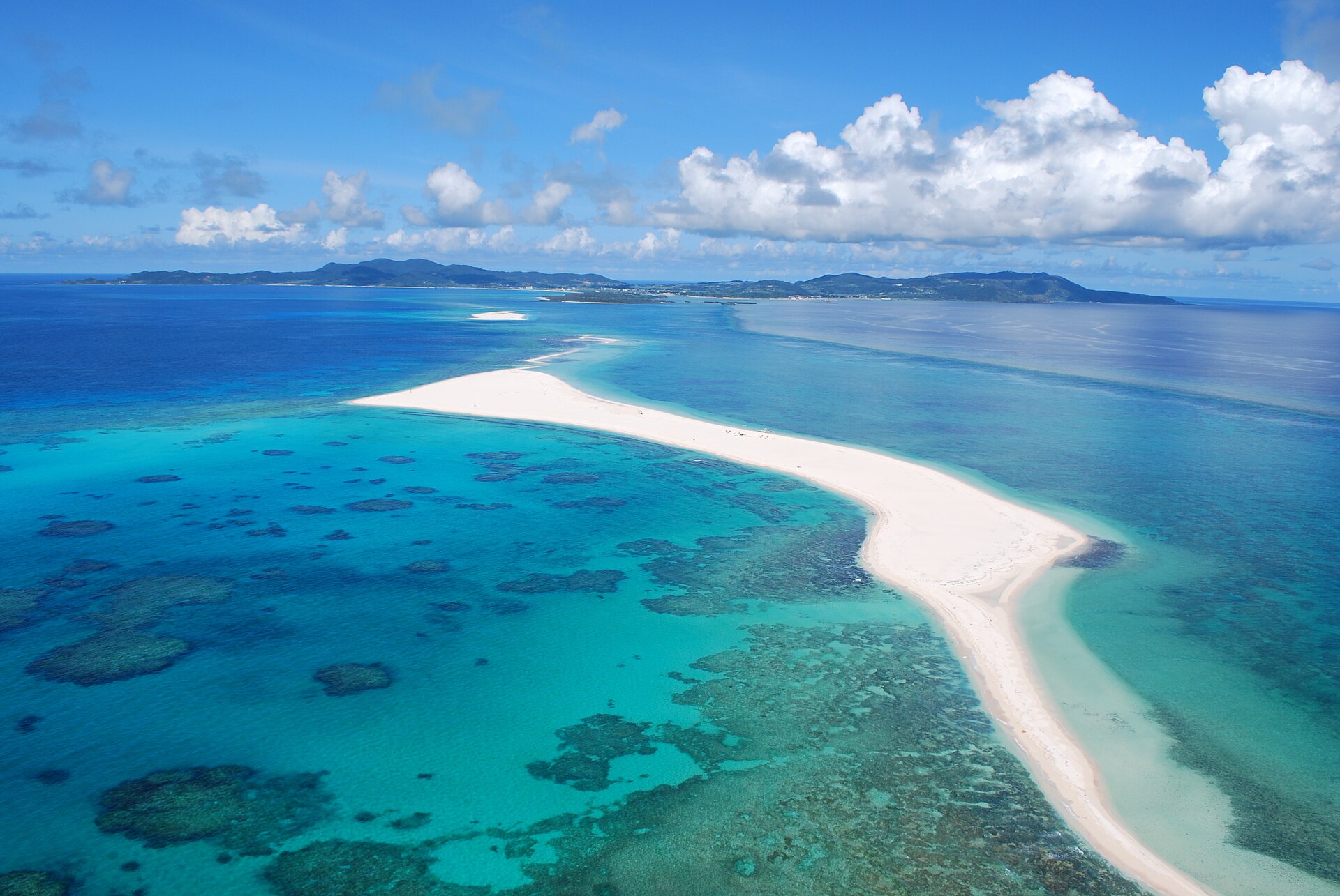
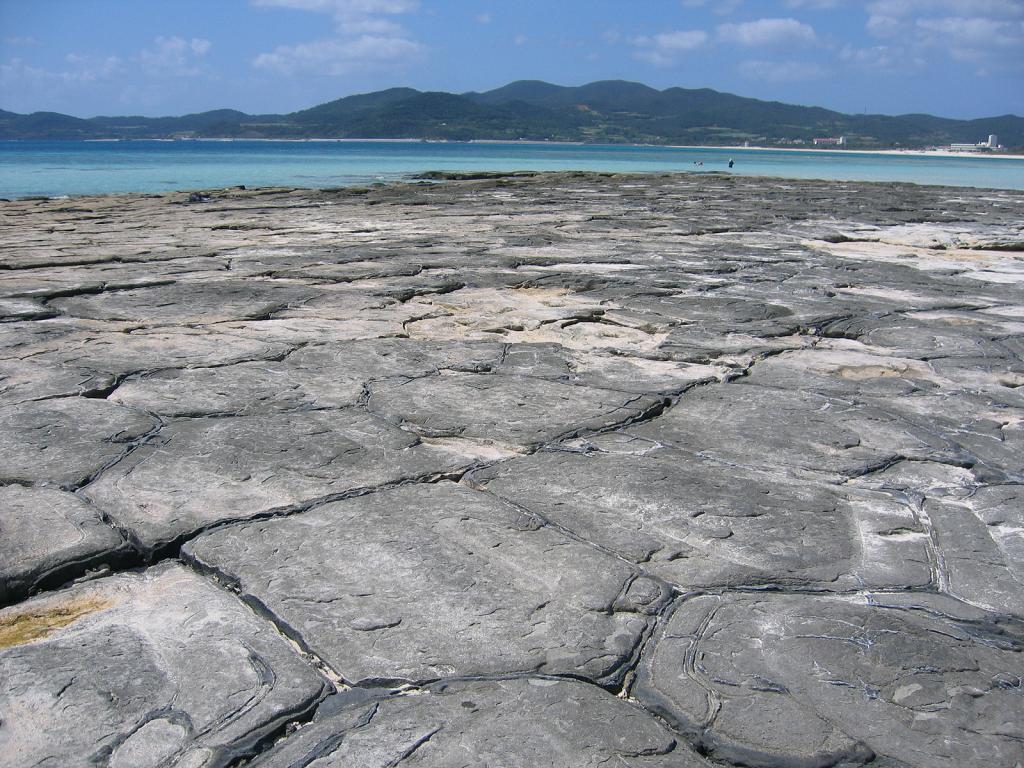
West of Okinawa's main island, Kumejima keeps its headline sight offshore: a bare coral sandbar reached only by boat. On land the shore at Ou Island cracks into a pavement of flat volcanic pentagons, and the island's own silk is still woven by hand.
- FromNaha Airport
- ~30 minFlight from Naha, then the island bus
- Get off atKumejima Airport (flight from Naha)
- From there
- Kumejima
The sweet spot
Kumejima is not a secret. It has its own airport, a daily flight from Naha and a run of hotels along Eef Beach. What it does not have is a crowd on the sandbar: the boats out to Hate-no-Hama carry small groups, and the bars are long enough that everyone aboard spreads out along them.
Where it is
3 more notes in Okinawa · open the map →What to look for — in walking order
- Eef Beachthe island's main beach on the east coast, with the hotels and the boat desks behind it
- Hate-no-Hamathree bare coral sandbars offshore, reached only by chartered boat
- Tatami-ishi, Ou Islandvolcanic rock split into flat pentagons and hexagons along the tideline
- Hiyajo Bantacliff-top viewpoint on the north coast, looking out over the sandbar
- Uegusuku Castle ruinsstone walls on the island's highest ridge, open to the sea on both sides
How to actually get there
- Naha Airport → Kumejima Airport (flight, about 30 minutes).
- Kumejima Airport → Eef Beach on the east coast (town bus, Airport Line, or rental car).
- Eef Beach → Hate-no-Hama (chartered boat, booked the day before or on arrival).
- Cross the bridge to Ou Island for Tatami-ishi, then north to Hiyajo Banta for the view back over the sandbar.
- Flight from Naha Airport
- Naha Airport →(flight, about 30 minutes)→ Kumejima Airport. The route is flown daily and is the ordinary way onto the island. The terminal is small, with the rental car desks inside, and Kumejima Town runs its own buses from the airport across to the Eef Beach side.
- Return from Kumejima Airport
- The same route flies back to Naha, and the last departure is an evening one rather than a late-night one, so check it before booking anything else into your final day. The ferry is the other way home if you would rather have the sea time and are not in a hurry.
About the place
The Ryukyu court knew this island as Kumi, the island of beauty, and the name still does the work of a description. Kumejima sits out west of Okinawa's main island, far enough that the water clears completely. Its best-known feature is not on the island at all. Hate-no-Hama is a run of three sandbars stretching about seven kilometres east of the coast, bare coral sand with nothing built on it. Closer in, the shore at Ou Island breaks into Tatami-ishi, a pavement of volcanic rock split into flat pentagons and hexagons. Silk weaving has gone on here since the kingdom era, dyed with island mud and island plants.
How to enjoy it
Boats for the sandbar leave in the morning and come back in the early afternoon, so put that first and keep the island's own coast for later in the day. Tatami-ishi shows itself properly at low tide, when the full pavement is out of the water. There is no shade on the sandbar at all, so a hat and water matter more than they sound.
Background & history
The name Kumi belongs to the Ryukyu kingdom, when the island sat on the sea road between Naha and China and was praised for its water and its harvests. Fortified sites were raised on the high ground during the kingdom's long century of local lords, and the ruins at Uegusuku stand higher than any other castle site in Okinawa Prefecture. The island's silk pongee comes from the same era. The mud-and-plant dyeing that gives it its dark sheen has been handed down on the island ever since.
Before you go
- Cash
- The beaches, Tatami-ishi and the castle ruins are all free to walk. Boat trips out to the sandbar are booked and paid for locally, and what they cost varies by operator and by season. Cash is the safer assumption on a small island, so draw what you need before you leave Naha.
- Good to know
- Typhoon season runs through late summer and early autumn, and both the flights and the sandbar boats stop when the weather turns. Sandbar trips are cancelled on rough days even when the island itself looks fine. The sandbars have no shelter, no shade and no drinking water.
- Another way
- Kume Shosen runs a ferry from Tomari Port in Naha to Kanegusuku Port on Kumejima, calling at Tonaki on the way. It is slower than flying but it takes cars, and it lands you on the west side of the island rather than at the airport.
- After you get off
- Kumejima Airport is the arrival point. The town's Airport Line bus crosses to Eef Beach on the east coast, and the rental car and taxi desks are inside the terminal; nothing on the island is more than a short drive from there.