Wakayama south · KushimotoNo.287★Open in map →
Hashigui-iwa
— the bridge piers that walk into the sea
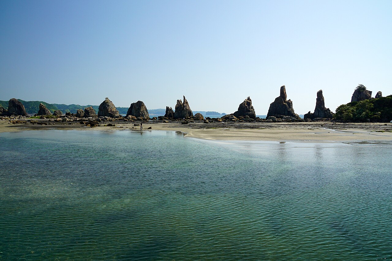
A row of some forty rock columns stretching 850 metres off the Kushimoto shore, designated both a national Place of Scenic Beauty and a Natural Monument.
- FromShin-Osaka Stn
- ~4 hr 20 minlimited express + 20 min walk
- Get off atKushimoto Stn
- From there
- Hashigui-iwa
The sweet spot
It is nationally designated twice over and sits inside Yoshino-Kumano National Park, but it is four hours by rail from Osaka on a line most visitors never board — so a formation this dramatic is usually shared with a handful of people and a large car park.
Where it is
21 more notes in Wakayama · open the map →What to look for
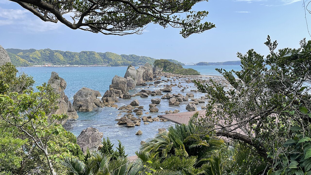
- The 850-metre rowForty-odd pillars in near-perfect alignment, running from the shore toward Kii-Oshima.
- Sunrise through the gapsThe row faces east, so at dawn the sun comes up between the rock columns.
- The tsunami bouldersBlocks fallen from the formation and carried inland by past tsunami, now scattered around the shore.
- Michi-no-Eki Kushimoto HashiguiiwaThe roadside station at the foot of the rocks, with parking, toilets and local produce.
How to actually get there
- Shin-Osaka Stn → Kushimoto Stn (JR Ltd. Exp. Kuroshio, ~4 hr)
- Kushimoto Stn → Hashigui-iwa (walk northeast along Route 42, ~20 min)
- Limited Express Kuroshio, then walk from the station
- Shin-Osaka Stn → (JR Limited Express Kuroshio, bound for Shirahama / Shingu, ~4 hr) → Kushimoto Stn → walk northeast along Route 42 toward Koza, sea on your right (~20 min). Total ~4 hr 20 min.
- Reverse, or push on to Cape Shionomisaki first
- Walk back to Kushimoto Stn (~20 min) and take the Kuroshio north toward Shin-Osaka. Northbound departures thin out through the evening, so check the last service before you set out — it finishes earlier than a mainline route would lead you to expect.
About the place
Kushimoto sits near the southern tip of Honshu, and just off its shore a line of rock columns runs out toward the island of Kii-Oshima as if someone had started a bridge and stopped. Local legend says someone did: Kobo Daishi made a wager with a mischievous demon that they could span the strait in a single night, and when the demon saw he would lose he faked a rooster's crow — the work stopped, and only the piers were left standing. The geology is stranger than the story. Magma pushed into the existing sedimentary layers as a long thin sheet and hardened there; over time the softer sediment around it eroded away, and the hard intrusion was left exposed as a row of pillars. Scattered around their base are boulders that broke off the formation and were carried inland — moved, it is thought, by the tsunami of past megaquakes.
How to enjoy it
Come at dawn — the row faces east and the sun rises directly into it, which is the one hour of the day when that oversized car park makes sense. Pair it with Cape Shionomisaki, the southern tip of Honshu, twenty minutes further on, or use Kushimoto as the overnight stop between Nachi Falls and Shirahama. Half an hour on the shore is enough unless you have come to photograph it.
Background & history
Hashigui means bridge piers, and people have read the row as an unfinished bridge for as long as they have written about it. The state protects it twice, as a Place of Scenic Beauty and as a Natural Monument, and it lies within Yoshino-Kumano National Park. It is also a geosite of the Nanki Kumano Geopark, so the intrusion-and-erosion account is set out on panels at the shore rather than left to the legend. The tsunami boulders around the base belong to that same record — physical evidence of the great quakes that have repeatedly struck this coast, which Kushimoto treats as a warning as much as a curiosity.
Before you go
- Cash
- Bring cash. The roadside station beside the rocks handles cards, but the local bus and the smaller stalls are simpler with coins.
- Good to know
- The rocks stand on a tidal shore. At low tide you can walk out among the nearer pillars, but the footing is loose rock and the water returns faster than it looks. Check the tide before stepping off the sand, and do not climb the columns.
- Another way
- A local bus runs from Kushimoto Stn along Route 42 and stops at Hashiguiiwa, right at the roadside station. A taxi from the station takes about two minutes.
- After you get off
- From Kushimoto Stn come out onto Route 42 and turn northeast, toward Koza. Keep the sea on your right for roughly 1.5 km; the roadside station car park and the rock row come into view together on the seaward side. About 20 minutes, flat the whole way.
Nearby notes
 663highland / CC BY 2.5
Onsen · Wakayama★★
Bokido
21.4 km · straight line
 Nekosuki / CC BY-SA 4.0
History · Wakayama★★★
Kumano Nachi Taisha
22.4 km · straight line
Distances are straight lines on the map, not travel times.