Mie · Owase · KihokuNo.1204★★Open in map →
Kumano Kodo Iseji Magose Pass
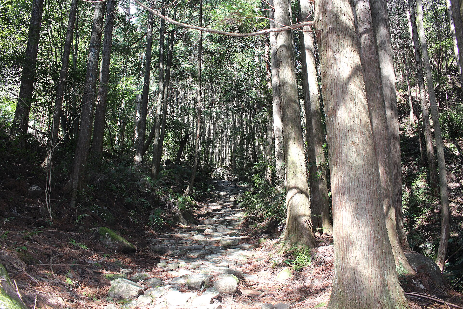
A World Heritage section of the Kumano Kodo's Iseji route, climbing out of Kihoku on heavy stone paving, through planted cedar and cypress, and down into the city of Owase. It is the flagstone stretch that appears on most of the route's leaflets.
- FromNagoya Station
- ~10-15 minLimited express + local bus
- Get off atOwase Station (JR Kisei Main Line)
- From there
- Kumano Kodo Iseji Magose Pass
The sweet spot
Mie's own material names Magose as the section to walk first on the Iseji, so this is a promoted route rather than a find. It stays calm because of its shape: walkers spread out along a climb inside closed forest, and there is no single viewpoint for everyone to gather on. The pass is also an ordinary footpath for the two towns it joins.
Where it is
17 more notes in Mie · open the map →What to look for — in walking order
- Yonaki Jizoa roadside stone Jizo near the foot of the climb, raised as a prayer for safe travel
- The stone bridge and the flagstonesa single slab thrown across a stream, with the paved road running away uphill behind it
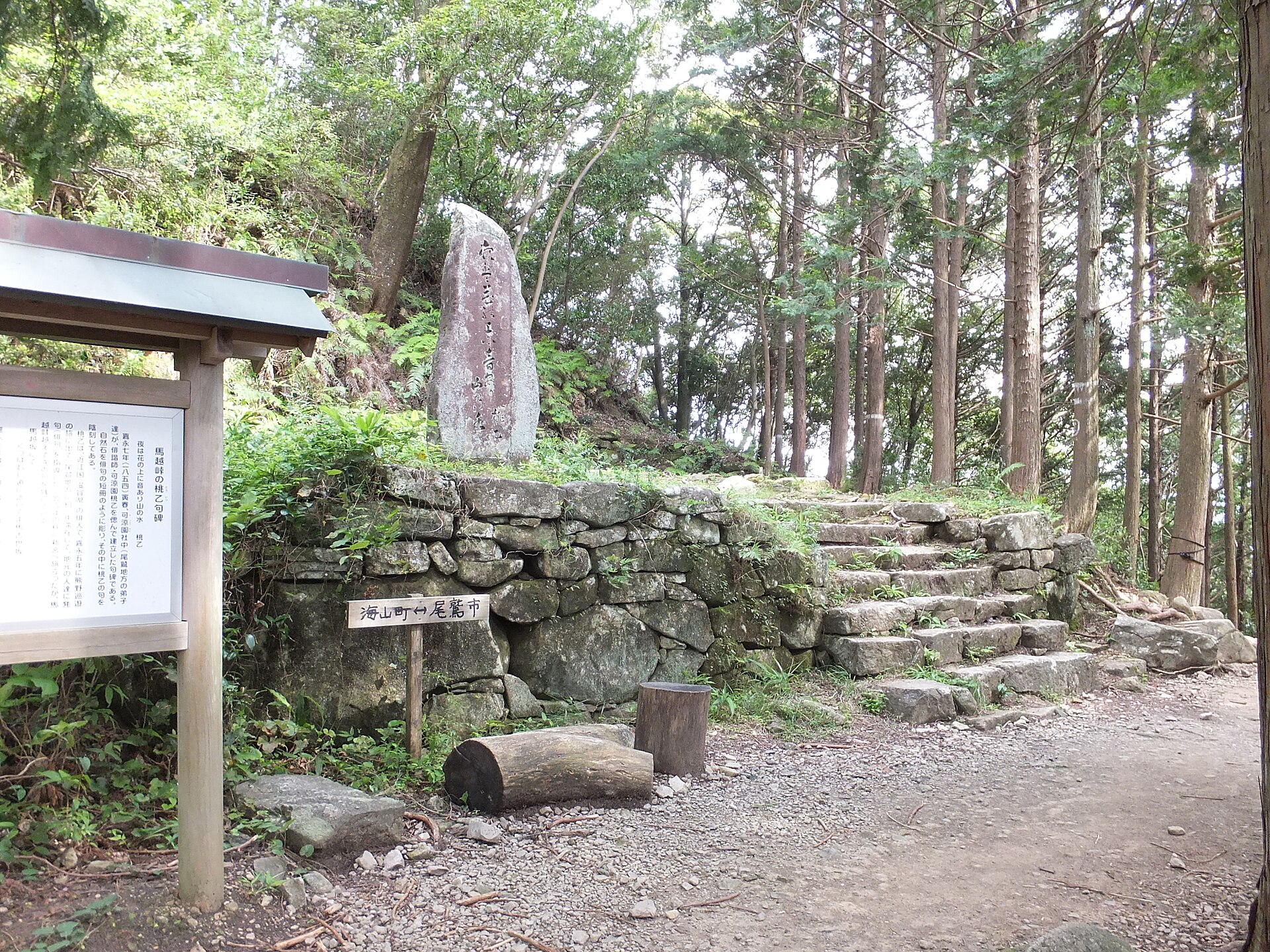
- Karyoen Toitsu's verse stonea haiku monument near the top, carved with a line on the sound of mountain water at night
- The pass and the Mount Tengura turnthe high point of the crossing, where a side trail leaves for the summit boulders
- Magose Park lookoutan arbour on the Owase side, with cherry and azalea in spring and bush clover in autumn
How to actually get there
- Nagoya Station → Owase Station (JR Kisei Main Line, limited express).
- Owase Station → Washige (Mie Kotsu bus toward Shimakatsu or Kii-Nagashima); the trailhead is at the stop.
- Climb the flagstones past Yonaki Jizo and the stone bridge to the pass.
- Descend the Owase side by Magose Park and walk into town to Owase Station.
- Nagoya Station to Owase, then the bus to Washige
- The Kisei Main Line runs south from Nagoya Station down the coast of the Kii Peninsula; the limited express is the through service and needs a limited express ticket on top of the fare. From Owase Station take a Mie Kotsu bus signed for Shimakatsu or Kii-Nagashima and get off at Washige, roughly ten to fifteen minutes out, for a fare the operator's own table lists at 410 yen. The entrance to the old road is beside the stop.
- Down into Owase and out by train
- The walk ends in the streets of Owase, so the return is from Owase Station rather than back over the pass. Trains on the Kisei Main Line thin out through the evening in both directions, so pick your train before you start the climb. The ticket office at Owase Station keeps set hours and closes well before midnight.
About the place
Magose Pass crosses the ridge that separates the town of Kihoku from the city of Owase, on the Iseji arm of the Kumano Kodo. Heavy natural stones lie across the road in overlapping courses, a surface built to survive rainfall among the heaviest in the country. Cedar and cypress grown for the Owase timber trade stand tight on both sides, so the climb is in shade almost the whole way. Measured from the roadside stop at Michi-no-Eki Miyama to Owase Station, the walk runs about five kilometres with the pass in the middle. From the top, side trails break off for Mount Tengura and Mount Binshi.
How to enjoy it
Mie's course notes and the regional tourism body both allow about three and a half hours for the crossing, so this is a half-day out rather than a stop between trains. Start from the Kihoku side and you climb in morning shade and finish downhill into Owase, where the station is the end of the walk instead of a return trip. Check the outbound bus times before you set off; that departure, not the walk, is what fixes the day.
Background & history
The Iseji is the arm of the Kumano Kodo that joins Ise Jingu to the three grand shrines of Kumano, crossing one headland ridge after another on the way south. Magose is the northernmost of the passes the road takes inside Owase. Near the top stands a verse stone cut for Karyoen Toitsu, a haiku poet of the late Edo period, and a small Jizo at the foot of the climb is prayed to for safe travel. In July 2004 the pass was inscribed with the rest of the route as part of Sacred Sites and Pilgrimage Routes in the Kii Mountain Range.
Before you go
- Cash
- The pass itself costs nothing to walk. The bus is paid on board, so carry coins and small notes; rail tickets are handled at the Owase Station counter. On the Kihoku side, Michi-no-Eki Miyama beside the trailhead is the last place to buy food and water before the climb.
- Good to know
- Mie Prefecture has a black bear advisory in force for the Owase and Kihoku area through the autumn, and its Kumano Kodo site publishes sighting reports and lends bear bells at tourist information counters — read the notices before you go. The stones are worn smooth and turn slippery in rain, which falls heavily here. Cover is continuous forest, so there is no view to walk out to if the weather closes in.
- Another way
- From Aiga Station on the same line, a bus signed for Segiyama reaches Washige in about five minutes, and the regional tourism body also describes walking that stretch, about half an hour. By car the Kisei Expressway leaves you minutes from the trailhead at the Miyama interchange, with parking at Michi-no-Eki Miyama.
- After you get off
- From Owase Station walk to the Owase-ekiguchi bus stop and take a bus toward Shimakatsu or Kii-Nagashima, getting off at Washige. The signed entrance to the old road is right there; Michi-no-Eki Miyama, the marked start of the course, is a short walk along Route 42.
Nearby notes
Distances are straight lines on the map, not travel times.